Why Aso's grassland has lasted a thousand years
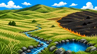
Left alone, Aso's grassland would revert to forest within a few decades. It has stayed open for over a thousand years only because people repeat a seasonal round of controlled burning, hay cutting, and grazing. Inside the vast bowl of Aso Caldera, this article traces how fire and water work together to sustain both the grassland and the people living on it.
Aso Caldera took shape through four major eruptions between roughly 270,000 and 90,000 years ago, forming a depression about 25km north-south and 18km east-west. The North Outer Rim traces its edge, while the Central Cone Group rises inside it. This article focuses on the grassland-maintenance work carried out inside that bowl, and the water that flows through it.
It looks at the seasonal roles of burning, hay cutting, and grazing, the hamlet-level teamwork that keeps them running, and how rivers such as the Kurokawa, which flows through the Aso Valley, connect to the grassland.
Three practices that keep the grassland open
Controlled burning in February and March, grazing from spring through autumn, and hay cutting each fall together hold back the forest — all run as hamlet-level teamwork.
草原景観grassland landscape
The grassland spanning the North Outer Rim and the Central Cone Group was first designated a national Important Cultural Landscape for a limited area in 2017, then expanded in 2021 and again in 2023 to reach its current name, 'Cultural Landscape of Aso: Grassland Landscape of the North Outer Rim and Central Cones.' That growing name traces how far the idea of 'grassland worth protecting' has expanded.
Source:阿蘇の文化的景観
野焼きcontrolled burning
Controlled burning takes place every February and March, clearing the grassland to hold back forest growth. Before the burn itself, villagers cut firebreaks in a task called 'wachigiri,' run as teamwork within each local hamlet association, or 'ku.' The rotating duty residents take on to run this kind of local affair is called 'kuyaku' — burning turns out to be less a single big event than an extension of everyday mutual aid within the hamlet.
Source:阿蘇くじゅう国立公園のストーリー
採草hay cutting
In autumn, grass that has grown tall over summer is cut in a practice called hay cutting. The dried grass becomes winter feed and bedding for cattle and horses, and the used bedding eventually turns to compost returned to the fields the following spring. If burning renews the grassland, hay cutting is the step that channels its bounty into daily life.
Source:阿蘇の文化的景観
放牧grazing
From spring through autumn, cattle and horses such as Akaushi are turned loose across the foothills of the outer rim and the Central Cone Group. Grazing supplies meat, but the livestock also hold back tree encroachment simply by eating the grass — maintaining the landscape itself becomes a goal here, unlike ordinary livestock farming.
Source:世界遺産の登録を目指して
Water that feeds the grassland, and world recognition
The Kurokawa River waters the Aso Valley, and in 2013 the FAO recognized the burning-grazing-haymaking-composting cycle as a Globally Important Agricultural Heritage System.
黒川Kurokawa River
The Kurokawa River, which runs through Aso City's own center and the Uchinomaki hot-spring district, rises on Neko-dake near Sakanashi in the Ichinomiya district and flows north through the Aso Valley. Aso City is also home to Toshinokami Spring, a long-used water source along National Route 57, while Miyagawa Valley in Ichinomiya counts as one of the headwaters of the separate Shirakawa river system. The Kurokawa joins the Shirakawa downstream at Tateno before flowing through Kumamoto City to the Ariake Sea.
Source:内牧温泉 黒川河川敷お散歩マップ
世界農業遺産GIAHS
In 2013 the UN Food and Agriculture Organization recognized the cycle itself — burning, grazing, hay cutting, and composting — as 'Aso's Grassland Conservation and Sustainable Agriculture,' a Globally Important Agricultural Heritage System (GIAHS). It marked international recognition that the thousand-year-old grassland is not merely scenery but a living agricultural system.
Source:阿蘇の草原の維持と持続的農業
FAQ
When does the controlled burning happen?
It usually takes place between February and March, but the exact date shifts year to year with weather and local circumstances. Check the latest schedule through the tourism association or municipal announcements.
Are all the grazing cattle Akaushi?
Akaushi, the Japanese Brown breed, is the best-known grazing animal in Aso, but the exact livestock kept varies by area and by grazing cooperative. This article focuses on the shared role grazing plays in maintaining the landscape.
Is GIAHS the same as World Heritage status?
No. The GIAHS recognition was granted by the FAO back in 2013, while Aso Caldera's proposed UNESCO World Heritage listing is still at the stage of being submitted for Japan's tentative list.
What's the difference between the Kurokawa and the Shirakawa?
The Kurokawa flows through Aso City's own Aso Valley and the Uchinomaki hot-spring district, while the Shirakawa is a separate river flowing through the Nango Valley on the Minami-Aso side. The two meet at Tateno before reaching the Ariake Sea via Kumamoto City.